



Flood Hazard Assessment
We assess how floodwaters may spread across a site, what controls their extent, and how potential flooding relates to the property, its access routes and proposed development areas.
Distance from a watercourse alone does not determine flood exposure
To understand whether a site may be affected by flooding, we assess elevation, valley geometry, potential water levels and available flow paths.
Two points at different distances from a river may have entirely different flood conditions
An area relatively close to a channel may lie on an elevated terrace or surface and remain above the water level assessed.
At the same time, a point farther away horizontally may lie in a low-lying area connected to the floodplain.
- Ground elevation.
- Valley geometry.
- Connectivity with the channel.
- Water level reached.
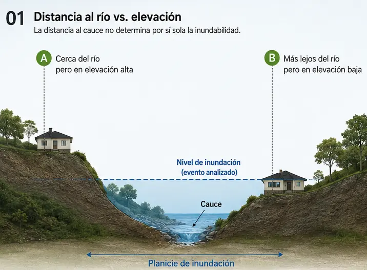
Being near a river does not automatically mean that a site is flood-prone, and being farther away does not guarantee that it is safe from flooding.
Flood extent depends on the interaction of the watershed, channel, terrain and infrastructure
Flooding is not controlled by a single variable. We integrate hydrological and hydraulic conditions with topography and the specific characteristics of the surrounding area.
Where the water comes from
Watershed size, gradients, land cover, drainage and rainfall response determine the discharges that may reach the area under assessment.
How flow is conveyed
The geometry of a river, stream, channel or drainage feature influences water levels, velocities and conveyance capacity.
Where water may spread
Small elevation differences can substantially change flow routes and the extent of potential flooding.
What may restrict or redirect water
Bridges, culverts, roads, fill and other structures may locally alter water movement and water levels.
What has happened before
CNE hazard maps, historical events, photographs and local observations provide context for understanding flood behavior.
What may be affected
The interpretation must consider buildings, development platforms, access, utilities and other areas relevant to the project.
Water does not follow property boundaries. Assessing flood exposure may require considering conditions upstream, on the property and downstream.
From the broader setting to the specific property
We begin by understanding the watershed and its surroundings, check site conditions and apply the level of analysis needed to answer the project's specific question.
Review the setting
We review the watershed, channels, hazard mapping, terrain, historical records and other available information to identify general conditions.
Verify site conditions
We inspect watercourses, drainage features, depressions, structures, access routes, fill and other elements that may affect water movement.
Analyze and integrate
We combine hydrological, hydraulic and topographic information with project details to identify areas requiring closer attention.
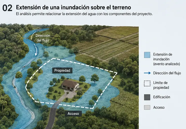
Knowing that a flood-prone area exists is not enough
The assessment should show how flood extent relates to what matters for the decision: buildings, development platforms, access roads, routes and utilities.
A property may still have usable areas while presenting a critical flood-related condition at its entrance or in one specific section.
- Property boundary.
- Buildings and development platforms.
- Access and evacuation routes.
- Watercourses and flow paths.
Not every project requires the same level of modeling. The scope depends on site complexity, available information and the decision the assessment must support.
Bridges, culverts and fill can alter water levels
A structure crossing a channel may locally reduce the flow area and change hydraulic behavior upstream and downstream.
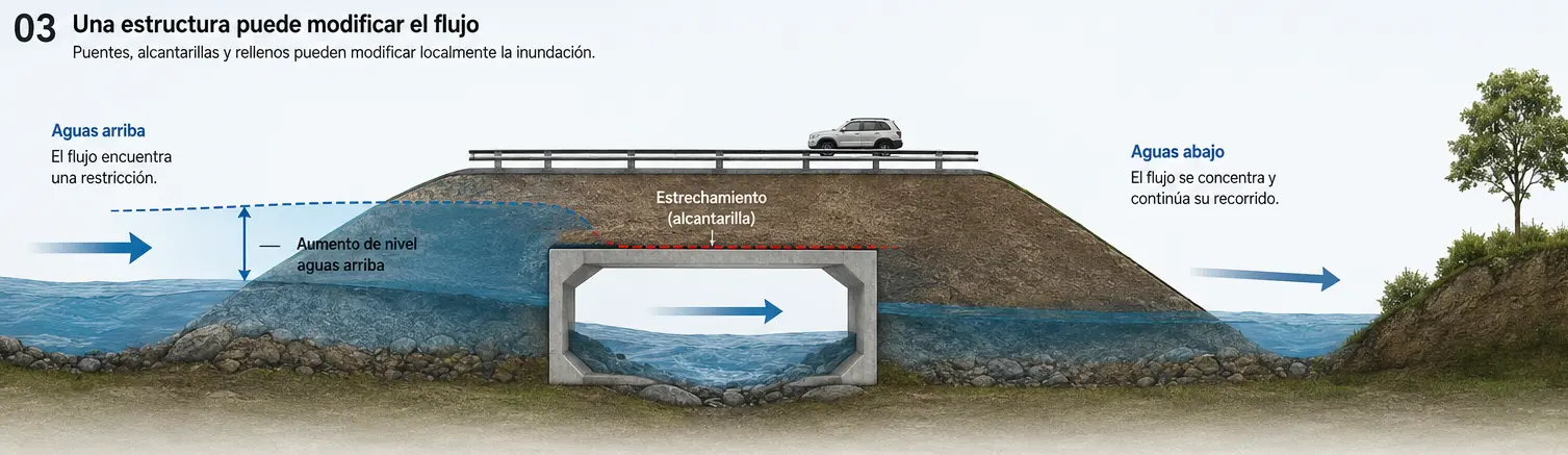
Water may accumulate
When the capacity of a structure is less than the incoming flow, water levels may rise upstream.
Structure geometry matters
Dimensions, blockages, fill and crossing configuration can change the capacity available to convey water.
Effects must be assessed together
Flow behavior beyond the crossing also depends on channel geometry and downstream hydraulic conditions.
When a structure is a controlling factor, a supplementary specific Hydraulic Study may be needed to assess its capacity and performance.
Findings should explain where water may reach and what that means for the project
We integrate results into a site-specific interpretation to identify potentially affected areas, site constraints and the need for further investigation.
Potentially flooded area
We delineate or interpret flood extent for the conditions or scenarios included in the assessment.
Relationship between water and ground elevations
Where the data allow, water levels can be compared with ground elevations and relevant project features.
Potentially affected features
We relate the inundation area to buildings, development platforms, access routes and other important development areas.
Factors controlling flooding
We identify channels, depressions, structures, fill and topographic configurations that help explain the observed flood extent.
Assessment limitations
We describe the conditions assessed, the quality of available information and uncertainties relevant to interpreting the results.
Define the next step
When an issue requires greater detail, we identify whether additional topography, hydrology, hydraulics or specific modeling would be appropriate.
A Flood Hazard Assessment is not, by itself, an official determination by the CNE
Institutional maps and historical records are important inputs, but Geo Costa Rica provides a technical interpretation focused on the conditions of the specific property and project.
Understanding flood exposure helps inform decisions before design or site works
The assessment can support property evaluation, project layout, access planning and decisions about additional hydrological or hydraulic investigations.
Assess a site before buying or developing
Helps identify how potential flooding relates to usable portions of a property.
Relate structures to terrain
Can inform the placement of platforms, buildings and other project components.
Determine whether project access may be affected
A project's main development platform may be outside the flooded area while its access remains vulnerable.
Hydrological Study
Estimates discharges generated by a watershed under the conditions and scenarios assessed.
Explore This StudyHydraulic Study
Examines how a given discharge behaves within a watercourse, channel, bridge, culvert or other hydraulic structure.
Explore This StudyNatural Hazard Assessment
Integrates flooding with other geological, geomorphological and territorial conditions relevant to the project.
Explore Natural HazardsHydrological Study → discharge. Hydraulic Study → flow behavior. Flood Hazard Assessment → spatial extent and potential effects on the site.
Frequently asked questions about flood hazards
Flood exposure results from interactions among water, terrain, watercourses and infrastructure; it cannot be established solely from proximity to a river.
Does being close to a river mean my property will flood?
Not necessarily. Ground elevation, valley geometry, water levels and flow paths may matter more than the horizontal distance from the channel.
Is a property outside the CNE flood map free from flood risk?
That should not be assumed. The mapping must be interpreted according to its scale, available historical evidence and the property's specific conditions.
What is the difference between a Hydrological Study and a Flood Hazard Assessment?
A Hydrological Study estimates discharges generated by a watershed. A Flood Hazard Assessment examines where water may spread and which features may be affected.
What is the difference between a Hydraulic Study and a Flood Hazard Assessment?
A Hydraulic Study examines water levels, velocities and flow capacity in channels or structures. Flood assessment focuses on the spatial extent of inundation and its relationship with the surrounding area.
Is HEC-RAS always necessary?
No. The level of modeling depends on the project's question, site complexity, available information and the resolution needed for decision-making.
Is topography important in a flood study?
Yes. Relatively small differences in elevation can alter flow paths and determine which areas lie above or below the water level being assessed.
Can a culvert or bridge make flooding worse?
They may locally alter water levels if they create a hydraulic restriction. The effect depends on geometry, capacity, blockages and upstream and downstream conditions.
Can the study indicate whether a building or access route lies within a flood-prone area?
Yes, when data quality and the level of analysis allow flood extent to be related to elevations and specific project components.
Do you need to know whether a property or project could be affected by flooding?
We can review its location, topography, watercourses, flooding history and project characteristics to determine the appropriate level of assessment.
We first clarify the setting and the question to be answered, then determine whether detailed hydrological or hydraulic studies or modeling are needed.