



Natural Hazard Assessment for Properties and Development Projects
We assess what a natural hazard means for a specific property, connecting maps, topography, geology, water, historical information and field observations with the actual conditions of the site and proposed project.
When should a property's natural hazards be assessed?
An assessment may begin with a mapped constraint, a question before investing or designing, an institutional request, or evidence observed directly on the property.
The property is already shown as affected
When CNE maps, municipal studies, a local land-use plan (Plan Regulador) or other spatial information show a hazard or condition affecting all or part of a property.
Buying or developing land
When we need to understand whether flooding, slopes, faults or other conditions could influence the intended use of the property.
Locating structures on the property
When we need to distinguish between areas before positioning buildings, platforms, access roads, cut-and-fill operations or other interventions.
A condition needs clarification
When an institution, specialist, previous study or evidence such as flooding, cracks or ground movement indicates that a closer investigation is needed.
A regional mapped constraint must be interpreted at property scale
Hazard maps and land-use zoning are essential tools for identifying conditions that warrant attention. However, their scale may differ considerably from the level of detail required to answer a question about a particular property or project.
Regional information
CNE, municipalities, land-use plans and other sources identify hazards or conditions across a broad area.
Specific property
We overlay the property and project to determine where the mapped condition actually intersects the site.
Greater detail
We incorporate terrain, geology, drainage, imagery, historical records and site observations according to the hazard being assessed.
Delineation
We determine whether the condition is consistent across the property or differs between areas.
Project
We relate the condition to the areas actually proposed for construction, access or other interventions.
Technical assessment
We document what the available evidence supports and where further investigation is needed.
A detailed study does not automatically remove an official restriction
A study can provide higher-resolution evidence to clarify how a condition manifests within the property and technically substantiate differences found.
Any subsequent change to official zoning, restrictions or determinations is subject to assessment and the applicable procedure by the competent authority.
Technical studies to assess natural hazards
When the question concerns a specific hazard, we carry out a focused investigation to understand how it manifests on the property and relates to the project.
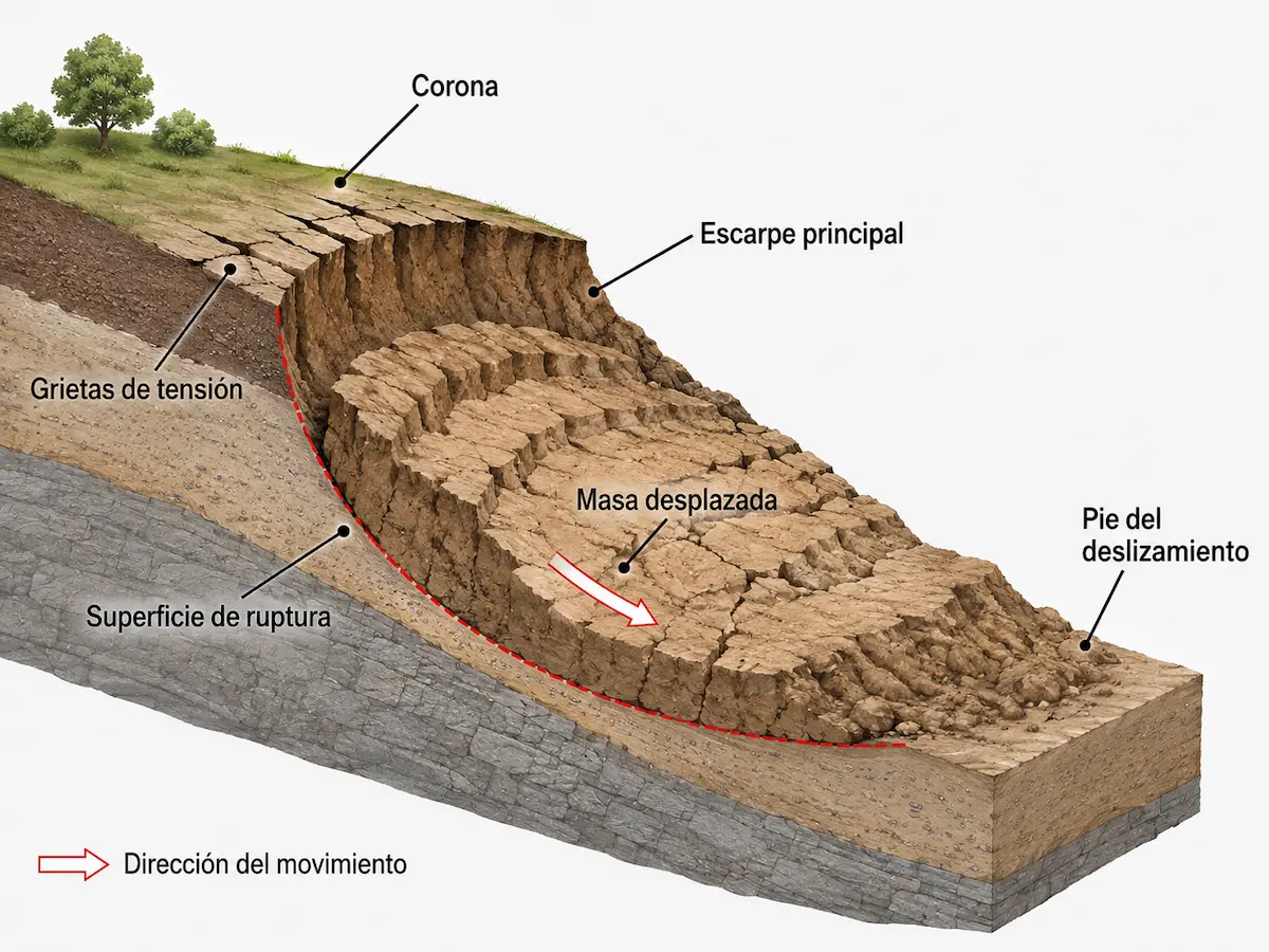
Slope Stability and Mass Movement Assessment
Examines gradients, materials, water, landforms and evidence of movement to understand slope behavior.
When is it needed?
Where there are steep slopes, cut slopes, cracks, scarps, landslide history or a mapped constraint associated with mass movements.
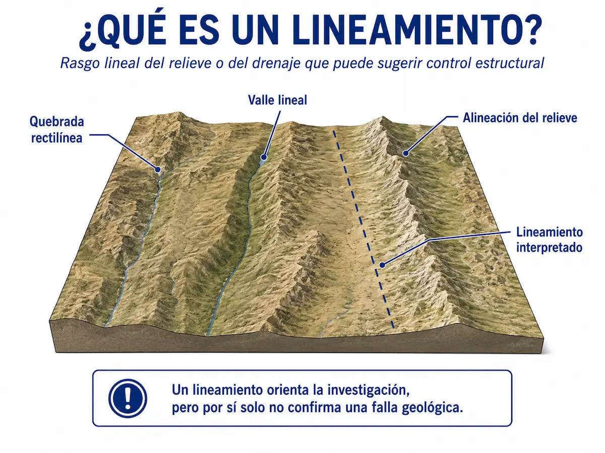
Faulting and Neotectonic Assessment
Investigates structures, lineaments and deformation evidence to establish what can actually be supported at property scale.
When is it needed?
Where a fault or lineament is mapped on or near the site and its location, significance and potential implications for the project need clarification.
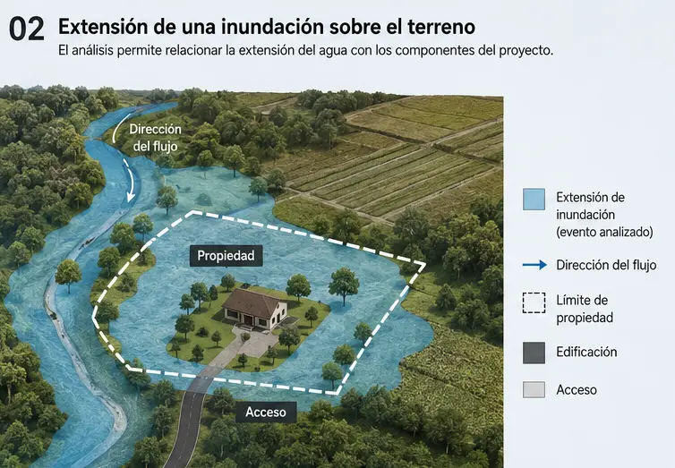
Flood Hazard Assessment
Examines how water may spread over the site and the relationship between potential flooding, the property, its access routes and planned development areas.
When is it needed?
Where streams, low-lying areas, previous floods or maps indicate that part of the site may be flood-prone.
First, let's identify the condition that needs to be addressed
We can review the location, available maps, site characteristics and project needs to determine whether one of these studies applies or whether another investigation is more appropriate.
From maps to field evidence
Maps help direct the search. Property-specific interpretation helps establish what that information actually means for the site and the proposed works.
Official and thematic information
We review hazard, geology, hydrography and land-use maps, along with other available sources, to identify reported conditions.
Landforms
Slopes, scarps, depressions, terraces, valleys, drainage patterns and elevation changes help refine the interpretation.
Imagery and previous records
Aerial photographs, satellite imagery and historical records can reveal floods, movements or changes that may no longer be apparent.
Site verification
We compare our interpretation with real field evidence, including materials, landforms, drainage, structures, deformation and other relevant conditions.
Other hazards may require analysis depending on the project location
Not every property is affected by the same processes, and not every hazard automatically warrants a separate report. The scope depends on actual site conditions and the decision the project needs to support.
Volcanic hazards and deposits
A property's position relative to volcanoes, hazard maps, deposits and historical records may require interpretation in the context of the site and project.
Erosion and landscape evolution
Gullies, concentrated erosion, scour and other processes may progressively alter certain parts of a property.
Coastal hazards
Some projects may need to consider shoreline dynamics, coastal erosion, marine flooding, tsunamis or other location-dependent processes.
Targeted investigation
When a different condition is identified, we first establish which phenomenon must be understood and what level of investigation is proportionate to the project decision.
The results should explain which parts of the property require consideration
A hazard may be present within a property without manifesting in the same way everywhere. We therefore relate it to the terrain, the evidence and the specific location of proposed works.
Site-specific information to understand ground conditions
We start with the project's question and add detail where necessary
Locate the property
Identify the site, the project and the condition requiring assessment.
Review information
Bring together CNE information, land-use planning, geology, terrain, hydrography and historical records.
Interpret the scale
Determine what existing information can resolve and what requires greater detail.
Verify the site
Compare the interpretation with local evidence when appropriate.
Delineate and interpret
Map relevant conditions and their relationship to the project.
Define next steps
Explain which conclusions are supported and where further investigation is necessary.
Natural hazards and properties
My property is shown as affected on a CNE map. Does the entire property have the same condition?
Not necessarily. Regional mapping is a reference and must be interpreted in light of its scale and the property's specific conditions. A site-specific study may provide greater detail and distinguish different areas of the property.
Can a study remove a restriction from a local land-use plan (Plan Regulador)?
Not automatically. A study can provide detailed technical information and support a more precise interpretation, but any official reassessment or modification is the responsibility of the competent authority under the applicable procedure.
Should hazards be assessed before purchasing a property?
It can be particularly useful when slopes, watercourses, mapped constraints, historical events or other conditions may affect the property's future use.
How do I know which technical study I need?
If the hazard is already identified, we can focus the study accordingly. When uncertainty remains, we first review the context and determine which process needs investigation.
Does every property require detailed studies?
No. The level of investigation should be proportionate to the condition, available information and the decision it needs to support.
Does identifying a hazard mean there is risk?
No. These are not equivalent concepts. A hazard describes the potential occurrence of a phenomenon; risk also depends on exposed elements, their vulnerability and potential consequences.
Is your property affected by a mapped constraint, or do you need a better understanding of site conditions?
We can review the location, available maps, zoning, previous findings and project characteristics to identify which condition needs investigation and at what level of detail.
Let's review your property
Send us the location, property survey plan, project information and any existing maps, mapped constraints or relevant records.