



Hydrogeology and Groundwater in Costa Rica
We study how groundwater is stored, moves and responds within aquifers, and how these conditions relate to wells, springs, infiltration, water quality and project development.
We combine territorial analysis, Geographic Information Systems, fieldwork, measurements and specialized testing with hydrogeological expertise to provide useful information for water resource planning, protection and management.
What Is Hydrogeology and What Can It Tell Us?
Hydrogeology studies how groundwater is stored, moves and responds underground, and how its behavior relates to geology, wells, springs, recharge and land-use activities.
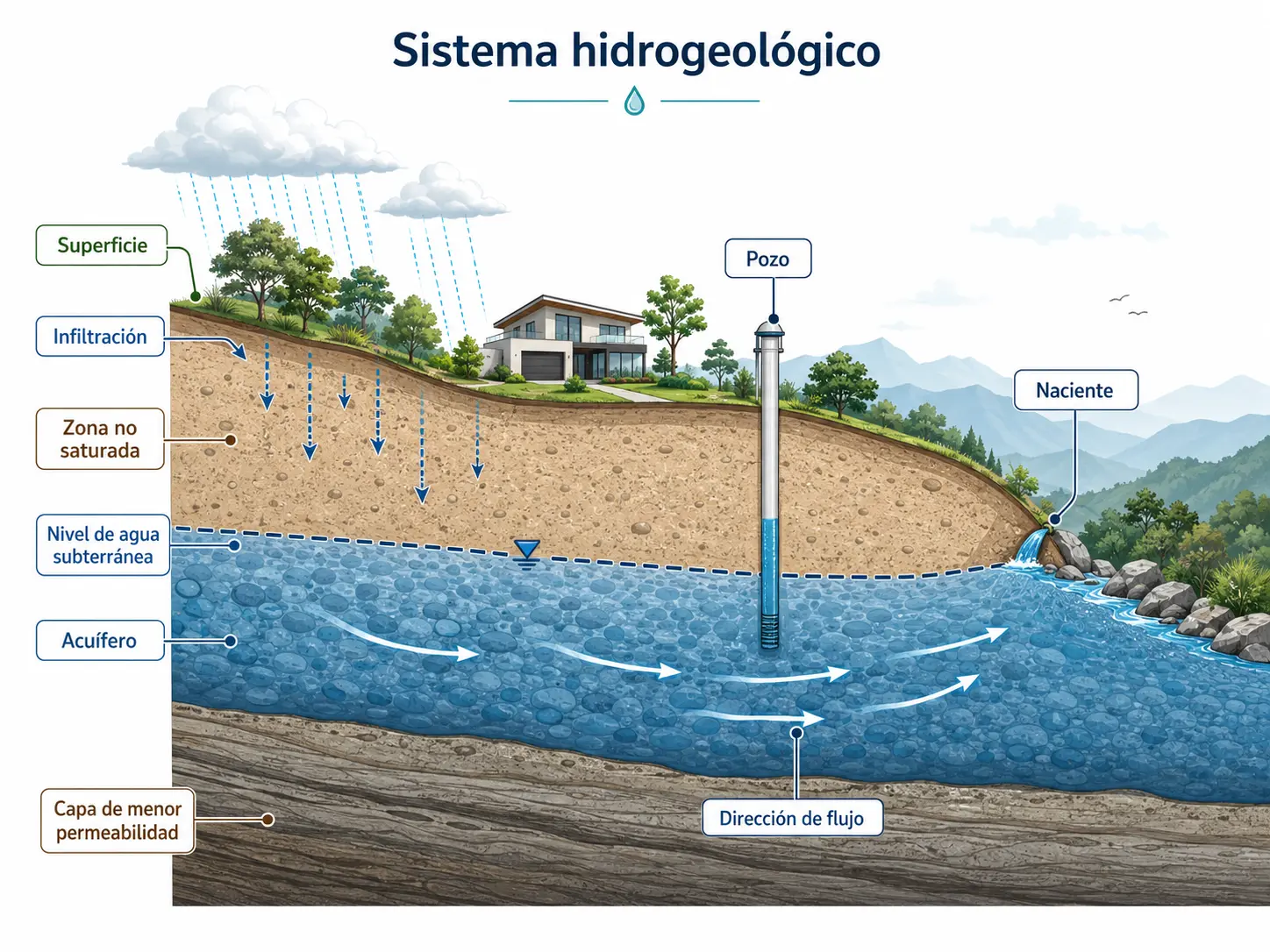
Groundwater is part of a system. Knowing only the location of a well, spring or water level is not always enough. Hydrogeological interpretation connects these data with subsurface characteristics and the overall functioning of the aquifer.
Geology Largely Controls Groundwater Behavior
The nature of geological materials, their permeability, continuity, fracturing and arrangement determine where water may be stored and which pathways it can follow underground.
View Geology, Soils and Geotechnical ServicesWhen Might You Need a Hydrogeological Assessment?
Hydrogeology may be relevant when a project depends on groundwater, interacts with it or requires understanding the relationship between a property, an aquifer, wells, springs or surface water bodies.
I Have a Well or Need to Understand a Water Abstraction Point
It may be necessary to assess water levels, pumping, aquifer response, interference between abstraction points or possible connections with nearby water bodies.
View Wells and Aquifer BehaviorThere Are Wells or Springs Near My Project
Location alone does not explain hydrogeological relationships. It may be necessary to understand the aquifer, groundwater flow direction, contributing areas and protection conditions.
View Aquifer ProtectionI Am Concerned About Possible Contamination
The assessment may consider aquifer vulnerability, potential contaminant sources, transport pathways and wells or springs that could be affected.
View Groundwater ContaminationMy Property or Project Is Near the Coast
In certain aquifers, the relationship between freshwater, salinity, recharge, abstraction and coastal aquifer behavior warrants investigation.
View Coastal Aquifers and Saltwater IntrusionI Need to Understand How the Aquifer Changes Over Time
A series of measurements helps interpret changes in water levels, abstraction points and other variables that a single observation cannot reveal.
View Hydrogeological MonitoringI Have Received a Request From a Regulatory Authority
We can review the technical question to be answered and determine whether a general hydrogeological study or a specific investigation of vulnerability, protection, interference or another groundwater condition is appropriate.
View Hydrogeological StudySpecialized Hydrogeology Services
Each service addresses a different need related to groundwater behavior, use, protection or monitoring.
Wells and Aquifer Behavior
Assessment of water levels, pumping, hydraulic response, abstraction effects and interactions between wells.
Aquifer Protection
Assessment of water sources, recharge, flow, contributing areas and territorial conditions relevant to their protection.
Groundwater Contamination
Assessment of vulnerability, potential contaminant sources, hydrogeological transport pathways and sensitive receptors.
Coastal Aquifers and Saltwater Intrusion
Interpretation of the relationship between freshwater, salinity, recharge, abstraction and coastal aquifer functioning.
Hydrogeological Monitoring
Monitoring water levels, abstraction points and other variables to interpret changes in the hydrogeological system over time.
Related Technical Studies and Reports
A hydrogeological investigation may require specific studies depending on the question a project needs to answer. Each report examines a different aspect of the aquifer, abstraction points, groundwater flow, vulnerability or resource protection.
Not every project requires the same studies. The scope depends on the hydrogeological issue, available information, site characteristics and required level of detail.
Understanding the Aquifer, Recharge and the Origin of Abstracted Water
These studies help interpret how the system works, how it is recharged and which areas contribute water to an abstraction point.
Hydrogeological Study
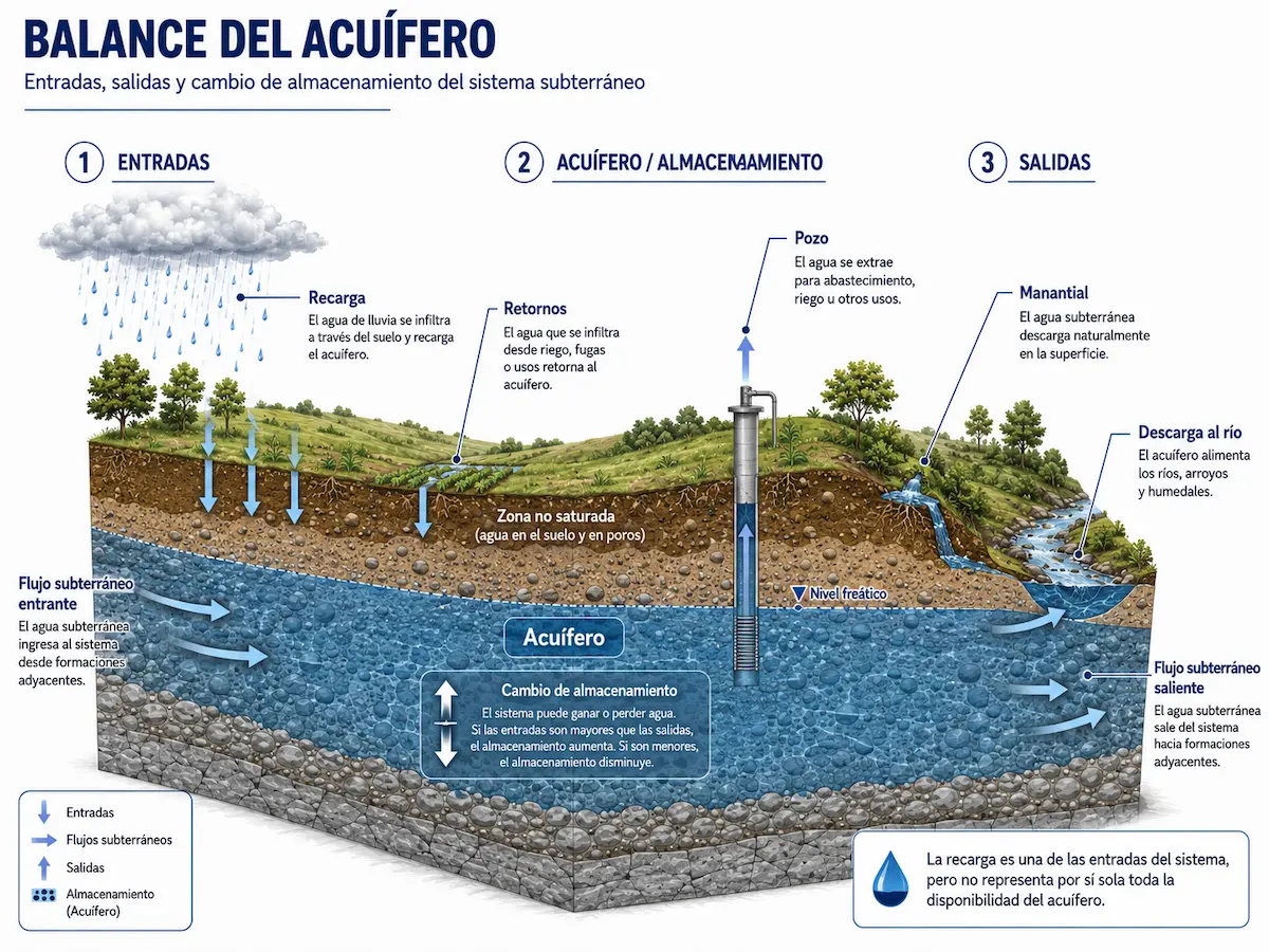
Combines geology, water levels, wells, springs and other evidence to characterize the aquifer and develop a conceptual model of the groundwater system.
View Hydrogeological StudyWater Balance
Examines precipitation, evapotranspiration, soil, runoff, infiltration and other components to estimate potential recharge to the system.
View Water BalanceFlow Tube and Capture Zone
Assesses which part of an aquifer contributes water to a well or spring, and how the abstraction point relates to groundwater flow direction.
View Flow Tube and Capture ZoneVulnerability, Contamination and Protection of Abstraction Points
These reports distinguish between an aquifer's natural susceptibility, potential contaminant transport and areas relevant to protecting wells and springs.
Aquifer Vulnerability Study
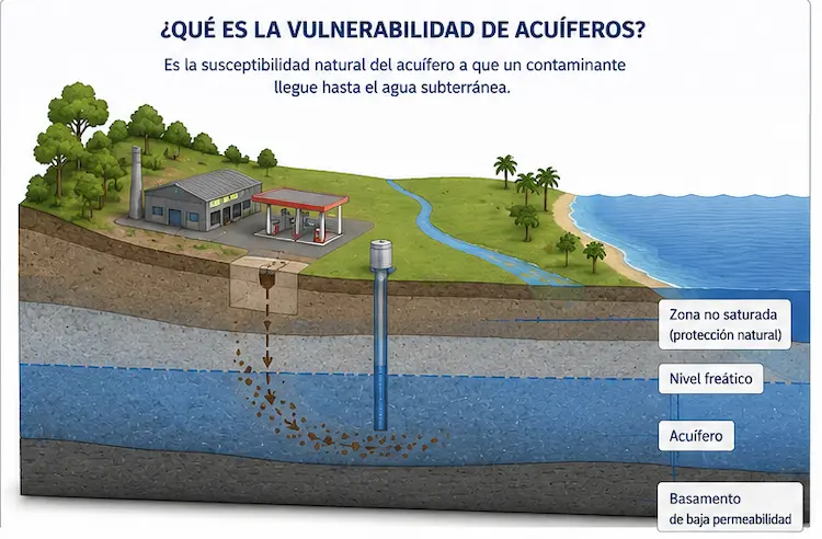
Assesses the natural conditions that determine how susceptible an aquifer is to the potential entry of contaminants.
View Aquifer VulnerabilityContaminant Transport
Examines how a substance may move from a potential source through the hydrogeological medium and reach a receptor, such as a well, spring or part of an aquifer.
View Contaminant TransportDelineation of Well and Spring Protection Zones
Integrates hydrogeological information to delineate areas relevant to protecting an abstraction point against potential sources of contamination.
View Protection ZonesPumping, Operational Setbacks and Coastal Aquifers
Some investigations focus on the effects of a particular abstraction point or on specific hydrogeological conditions in its surroundings.
Study of Interference Between Wells and Water Bodies
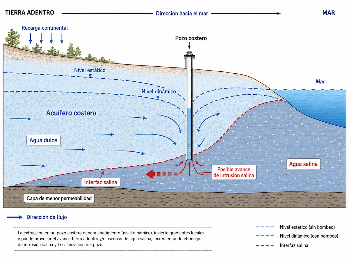
Evaluates whether drawdown caused by pumping at one abstraction point may affect nearby wells or water bodies under the hydrogeological and operating conditions assessed.
View Interference StudyStudy to Reduce the Well Operational Setback (ROP)
Examines hydrogeological conditions around a well to provide technical support for a possible reduction of its operational setback (Retiro Operacional del Pozo, ROP), where applicable.
View ROP Reduction StudySaltwater Intrusion Risk Study
Assesses whether hydrogeological conditions and the abstraction regime may favor saline water affecting a well or coastal aquifer.
View Saltwater Intrusion RiskOther Investigations Can Inform the Assessment
Depending on the project's objectives, a hydrogeological investigation may draw on studies from other technical disciplines. Although these are not part of the Hydrogeology menu, they can provide measurements needed to interpret the system.
Pumping Test
Evaluates the response of a well during controlled pumping and provides information on the hydraulic behavior of both the well and the aquifer.
View Pumping TestInfiltration Test
Measures infiltration behavior of the ground when this parameter is relevant to the investigation.
View Infiltration TestSite Geological Study
Geological characterization provides information about the units that store, transmit or restrict groundwater movement.
View Site Geological StudyRiver and Spring Discharge Measurement
Flow measurements may provide information about natural discharge or interactions between surface water and groundwater when required by the study.
View River and Spring Discharge MeasurementThe goal is not to accumulate studies, but to select the investigations that genuinely answer the project's hydrogeological questions.
How Do We Study a Hydrogeological System?
A hydrogeological investigation combines existing information, spatial analysis, field observations and measurements to develop a coherent interpretation of groundwater behavior.
Review Existing Information
We gather previous studies, geological information, well records, maps and other available data.
Analyze Spatial Relationships
We connect terrain, wells, springs, geology and other variables using spatial analysis tools.
Verify in the Field
We compare existing information with geological and hydrogeological conditions observed directly on site.
Measure Where Needed
Depending on the issue, the investigation may include water-level measurements, infiltration tests , discharge measurements , pumping tests or other measurements.
Interpret the System
We integrate the findings to build a conceptual model and answer the hydrogeological question under investigation.
Why Might Groundwater Matter to Your Project?
Hydrogeological conditions may influence decisions about water supply, sanitation, the location of works, excavations and protection of water resources.
Water Sources for a Project
Hydrogeological context helps interpret aquifers, existing abstraction points and conditions relevant to a potential groundwater source.
Infiltration and Groundwater
Soil, permeability and groundwater depth may be relevant when assessing solutions that rely on infiltration processes.
Excavations and Groundwater Levels
Groundwater depth may matter when excavations, underground structures or other works reach deeper ground levels.
Wells, Springs and Aquifers
The presence of water sources may require understanding how they relate to the project and identifying conditions that should be considered during planning.
Hydrogeology and Regulatory Procedures
Hydrogeological information may provide technical support for different assessments, permits or regulatory procedures, depending on the type of project, its location and water-resource conditions.
A hydrogeological study and a regulatory procedure are not the same. The study answers a technical question about groundwater. Its findings may subsequently support an assessment, application or request from the competent authority when required by the project.
Understand the Hydrogeological Issue First
The scope must respond to the specific question: aquifer behavior, interference between abstraction points, protection of a water source, vulnerability, potential contamination, groundwater levels or another particular condition.
When the Procedure Depends on Aquifer Vulnerability or Protection
Some situations require assessing aquifer vulnerability, areas related to the protection of abstraction points, or reviewing an existing hydrogeological classification in more detail. The results may support a later application or form part of a specific SENARA procedure.
When Hydrogeological Analysis Supports a Regulatory Procedure
Depending on the case, hydrogeological studies may provide information for procedures before SENARA or the Dirección de Agua of MINAE. We first review the project's objectives and the authority's requirements to determine which studies, documents and procedures are actually needed.
First, we identify the hydrogeological issue to be resolved; then we determine the technical study and, only when appropriate, the related regulatory procedure.
Frequently Asked Questions About Hydrogeology and Groundwater
These are some of the questions most frequently asked when a property, well or project needs a better understanding of its hydrogeological conditions.
What Is a Hydrogeological Study?
It is a technical investigation to understand groundwater conditions within a defined area. It may integrate geology, wells, groundwater levels, flow, recharge, fieldwork and other sources of information, depending on its objectives.
When Is a Hydrogeological Study Needed?
It may be needed when a project depends on groundwater, relevant wells or springs are present, a potential impact must be investigated or an authority requests specific hydrogeological information.
Can a Hydrogeological Study Guarantee That I Will Find Water?
No. An assessment can help interpret geological and hydrogeological conditions and guide an investigation, but the actual yield of a new well can only be determined after drilling and evaluating its performance.
Does a Nearby Well Mean My Property Also Has Groundwater?
Not necessarily. A nearby well provides useful information, but its depth, geology, aquifer and the continuity of geological materials must be considered before extrapolating conditions to another property.
What Is the Water Table?
In general, it is the upper surface of the saturated zone in an unconfined aquifer. Its depth can vary between locations and over time.
What Is the Difference Between Hydrogeology and Geotechnical Engineering?
Hydrogeology focuses on groundwater behavior. Geotechnical engineering examines the properties and mechanical behavior of soil and rock in relation to construction works. Both disciplines complement each other in some projects.
Is an Infiltration Test the Same as a Hydrogeological Study?
No. An infiltration test measures how water enters soil or near-surface materials under specific conditions. A hydrogeological study has a broader scope and seeks to interpret groundwater behavior within the system.
What Does It Mean for an Aquifer to Be Vulnerable?
It means that its natural conditions may make it easier or harder for a substance at the surface to reach groundwater. Vulnerability does not, by itself, mean that contamination is present.
What Do You Need to Know About Groundwater at Your Project Site?
Share the location, project type and available information. We can conduct an initial review and help determine which hydrogeological analysis or study may be appropriate.